Geographic Information Systems (GIS)
Geographic Information Systems (GIS)
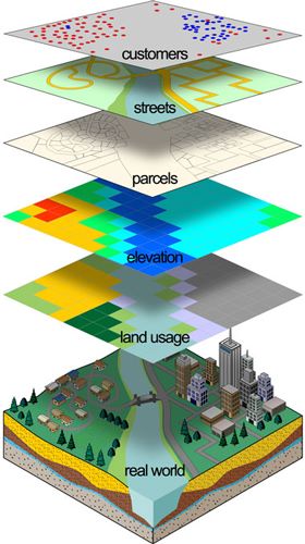
Geographic Information Systems (GIS) provide an accurate, efficient and cost-effective solution to manage spatial data. Our GIS department offers a broad range of GIS services. Because we are a multi-faceted geospatial firm, we understand the use of GIS technology as applied to the architectural, communication, construction, engineering, local government, public safety, public works, real estate, telecommunications, transportation, urban planning, utilities, and water resources market sectors.
Integrating with the latest technology, SINTECHS houses the capabilities of bringing this service to you in a affordable and useful manner that creates efficiency and focus to your internal planning objectives.
Geographic information is the key to better decision making. Just about everything a community, business or agency does, whether in the day to day or long-term planning is related to its geography. Understanding your surroundings can be difficult unless they can be organized in an interactive and visual environment.
We specialize in providing this to you in a user-friendly online platform viewable on desktop and mobile devices.
We work with our clients and support staff to help them better understand its concept but most importantly how to use GIS to be useful to their organization. Below is a list of the services we offer
- GIS project management and technical support
- Needs Assessment Report preparation
- Zoning map preparation
- Parcel mapping
- Sanitary sewer mapping
- Storm sewer mapping
- Watershed map compilation for hydrologic studies
- Emergency evacuation plan preparation
- Road program mapping plans for municipalities
- GPS field locations
- Gas Mapping
- Waterline Mapping
- Fire hydrant Mapping
CONTACT INFO
- Address: MIddle East Commercial Centre Office #40, FIfth Floor Madinat AL Umal, Al Khobar Kingdom of Saudi Arbia.
- E-mail: info@sintechs.com